
News Summary
Central Florida faces a mix of severe weather conditions, including a confirmed tornado in Lake Mary causing minor damage, along with forecasts for storms and rain throughout the week. As the region prepares for hurricane season starting June 1, residents are urged to stay alert for changing weather patterns and possible thunderstorms, particularly in the afternoons. A rare cold front is expected to bring a slight relief from humidity by the weekend, but increased rainfall is predicted mid-week.
Central Florida is experiencing a mix of weather conditions, including a recent tornado touchdown near Orlando and an prediction of rain and storms in the coming days. Residents are advised to stay alert as weather patterns shift and daily rainfall becomes more likely this week.
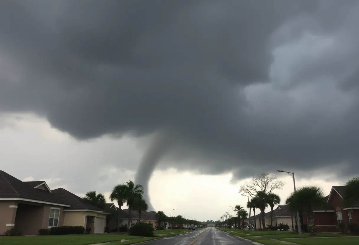
Tornado Touchdown Confirmed North of Orlando
A tornado was confirmed to have touched down north of Orlando in Lake Mary around 9:30 a.m. on Saturday. The incident was marked by wind speeds reaching nearly 70 mph. There was a tornado warning in effect for Sumter County at the time, which has since expired. Minor damage occurred as a result of the tornado, with reports of trees down at the Sweetwater Clubhouse tennis courts located north of Wekiva Springs Road. Additionally, Seminole County Fire Rescue confirmed it was assisting with damage assessments along the 2100 block of Blue Iris Place.
Current Weather and Immediate Forecast
Today, residents of Central Florida can expect more hot weather with highs in the low 90s inland and upper 80s closer to the coast. Feels like temperatures could reach the triple digits, putting the region under a marginal risk of severe weather. Scattered storms are possible between 1 p.m. and 10 p.m. today, with potential threats including lightning, small to medium hail, and wind gusts up to 60 mph. However, these isolated thundershowers will begin to taper off this evening, leading to overnight lows settling into the mid-70s.
Outlook for the Week
Tomorrow is expected to bring a mix of sun and clouds, along with a slight chance of afternoon thunderstorms. High temperatures will rise into the low 90s, as humidity persists, pushing the heat index close to 100 degrees. Rain chances will markedly increase from Wednesday through Friday, with scattered afternoon storms likely across the region. Some of these storms could be strong, capable of producing gusty winds or hail.
As a rare late-May cold front moves through the area on Saturday, humidity levels are forecasted to drop, and rain chances are expected to decrease, resulting in slightly cooler temperatures. The incoming cold front will signal a change as Sunday, which marks June 1 and the official start of hurricane season, is anticipated to be pleasant across much of Central Florida.
Preparation for Hurricane Season
Next week, higher rain chances are likely to emerge, indicating the onset of Florida’s rainy season characterized by daily afternoon and evening storms throughout the summer months. Fortunately, no tropical development is forecasted in the Atlantic basin for this week. However, in the eastern Pacific, Tropical Storm Alvin may be on the verge of formation and could intensify into a hurricane as it moves away from Mexico.
Key Takeaways
- Tornado confirmed in Lake Mary with minimal damage reported.
- Current weather includes high temperatures and a chance of scattered thunderstorms.
- Increased rain chances expected mid-week through Friday, with a rare cold front arriving Saturday.
- First day of June marks the beginning of hurricane season, though no significant threats currently exist.
Residents are encouraged to monitor local forecasts and stay informed about conditions as they change throughout the week. Emergency services remain on standby to assist with any weather-related incidents.
Deeper Dive: News & Info About This Topic
- Fox 35 Orlando: Orlando Weather Forecast – May 26, 2025
- Wikipedia: Tornado
- Click Orlando: Heat Feels Like 100 Degrees
- Google Search: tornado weather orlando
- NBC Miami: Tornado Touches Down Near Orlando
- Encyclopedia Britannica: Severe Weather
- WPBF: Florida Tornado Touches Down North of Orlando
- Google News: tornado Lake Mary
- WESH: Strong Storms in Central Florida
- Google Scholar: Florida weather severe
- Fox 35 Orlando: Orlando Weather Forecast – May 27, 2025
- Encyclopedia Britannica: Hurricane

Author: STAFF HERE PETERSBURG WRITER
The ST PETERSBURG STAFF WRITER represents the experienced team at HEREStPetersburg.com, your go-to source for actionable local news and information in St Petersburg, Pinellas County, and beyond. Specializing in "news you can use," we cover essential topics like product reviews for personal and business needs, local business directories, politics, real estate trends, neighborhood insights, and state news affecting the area—with deep expertise drawn from years of dedicated reporting and strong community input, including local press releases and business updates. We deliver top reporting on high-value events such as Grand Prix of St. Petersburg, Localtopia, and SHINE Mural Festival. Our coverage extends to key organizations like the St. Petersburg Area Chamber of Commerce and St. Pete Downtown Partnership, plus leading businesses in finance, manufacturing, and healthcare that power the local economy such as Raymond James Financial, Jabil, and Bayfront Health St. Petersburg. As part of the broader HERE network, including HEREJacksonville.com, HEREOrlando.com, HERETallahassee.com, and HERETampa.com, we provide comprehensive, credible insights into Florida's dynamic landscape.